
I've finally got maps sorted so you can see the exact location of the places. The satellite images over certain places in Ireland is not great but you should get an idea at least. This week we are turning to Offaly.
Location – West of Hardyman mountain in the Slieve Bloom Mountains.
OS: S 166 976 (map 54)
Longitude: 7° 45' 9.2" W
Latitude: 53° 1' 43.91" N
See map at the bottom of the page.
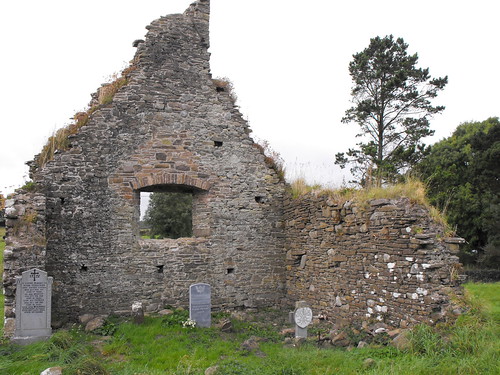
Description and History – This site is somewhat frustrating in that I couldn’t really find anything out about its history. The present remains of the church are medieval but it is believed that this was built on a much earlier Christian foundation which is attributed to St Molua and to whom the nearby holy well is attributed. St Molua is also associated with and allegedly buried at Kyle in Co. Laois. The remains of the medieval church consist of the West gable end and portions of the N and S wall. The surviving gable stands to full height with portions of the bellcote remaining. It really is a very attractive ruin within a nicely kept graveyard.
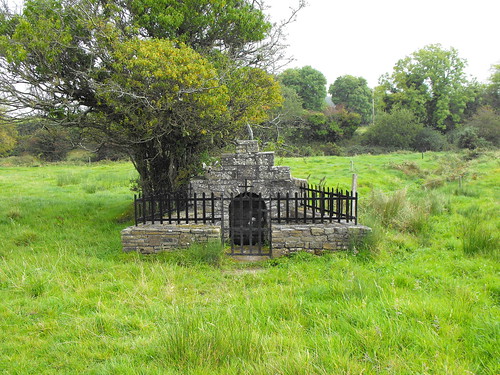
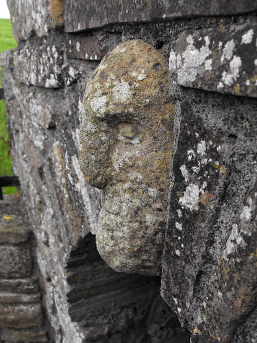
The holy well sits in the field to the rear of the graveyard. It can be accessed via a gate next to the entrance to the graveyard. The field can be a little boggy but it’s well worth making your way there because it is a nice little well. The enclosure is modern but very nicely done with the face of the saint represented on the face of the well which is very similar to Cumber Upper which is also in Offaly. The rag tree sits next to the well and only has a few rags attached to it. I get the impression that this well is not widely used but somebody is going to the effort of keeping it well maintained which is really great to see. When you see holy wells like Anatrim in Laois, which is barely identifiable, this is a nice sight.
Difficulty – The church is right on the side of the road with plenty of space for parking. The well is a little harder to get to depending on the weather as it can get boggy.
This post originally appeared on 'The Standing Stone' and can be accessed by clicking here.

I love the shape of this Church. The ruined bellcote gives it an unusual shape I think.

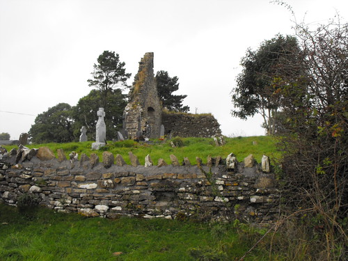
Looking at the ruin from the other side.


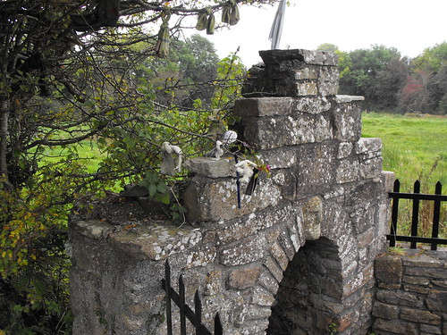
The holy well in the adjacent field. I think this has been tastefully done.


The face of the saint.


You can see some of the rags tied to the branches of the tree here.
Location – West of Hardyman mountain in the Slieve Bloom Mountains.
OS: S 166 976 (map 54)
Longitude: 7° 45' 9.2" W
Latitude: 53° 1' 43.91" N
See map at the bottom of the page.
Description and History – This site is somewhat frustrating in that I couldn’t really find anything out about its history. The present remains of the church are medieval but it is believed that this was built on a much earlier Christian foundation which is attributed to St Molua and to whom the nearby holy well is attributed. St Molua is also associated with and allegedly buried at Kyle in Co. Laois. The remains of the medieval church consist of the West gable end and portions of the N and S wall. The surviving gable stands to full height with portions of the bellcote remaining. It really is a very attractive ruin within a nicely kept graveyard.
The holy well sits in the field to the rear of the graveyard. It can be accessed via a gate next to the entrance to the graveyard. The field can be a little boggy but it’s well worth making your way there because it is a nice little well. The enclosure is modern but very nicely done with the face of the saint represented on the face of the well which is very similar to Cumber Upper which is also in Offaly. The rag tree sits next to the well and only has a few rags attached to it. I get the impression that this well is not widely used but somebody is going to the effort of keeping it well maintained which is really great to see. When you see holy wells like Anatrim in Laois, which is barely identifiable, this is a nice sight.
Difficulty – The church is right on the side of the road with plenty of space for parking. The well is a little harder to get to depending on the weather as it can get boggy.
This post originally appeared on 'The Standing Stone' and can be accessed by clicking here.

I love the shape of this Church. The ruined bellcote gives it an unusual shape I think.
Looking at the ruin from the other side.

The holy well in the adjacent field. I think this has been tastefully done.


The face of the saint.
You can see some of the rags tied to the branches of the tree here.
View The Standing Stone in a larger map
![Reblog this post [with Zemanta]](https://lh3.googleusercontent.com/blogger_img_proxy/AEn0k_uAosmh_ffJjrQ-P7vEsSfZ8feT7o3onGzAENCLTe6iXB72krxEIuEwowx20chyYml5iUf2A89SHj29eEz6TuXDcdiEVEuGeuDWPpHSpygZeMq-bYRCyCRK7GtAkc_tqwSW0Wg9Fzu_GZ-o8tqILEFv=s0-d)


